nostalgeo wins the audience award at Apps For Europe
After winning AppsforGeo and AppsforFlanders, nazka's nostalgeo also won the audience prize at Apps for Europe.
read more
2 march 2026
Looking back at 2025: a diverse year full of momentum
Over the past year, Nazka confirmed its role as a reliable partner for data‑driven map solutions. As always, it was a year with a lot of variety, from European innovation projects to very concrete applications close to the end user.
In the field of European research, we finalised the beta applications for two EU Horizon projects: Wimby, which enables users to explore wind energy potential and constraints across Europe and to simulate hypothetical wind farms; and Buildspace, which allows users to map flood scenarios, simulate the associated damage, and compare them for areas across Europe.
In addition, we further expanded our collaborations in Flanders and Belgium. Together with Sport Vlaanderen, we created our first designs for physical maps for the well‑known start panels of running, MTB and other routes. Within the federal Shift Your Mobility projects, both NaarJobs and Velopark received a thorough makeover. And for the intervention application INA, we welcomed a seventh fire service zone (Fluvia) and introduced the INA Geodata Interface, which makes working with geodata for the fire service zones considerably more efficient.
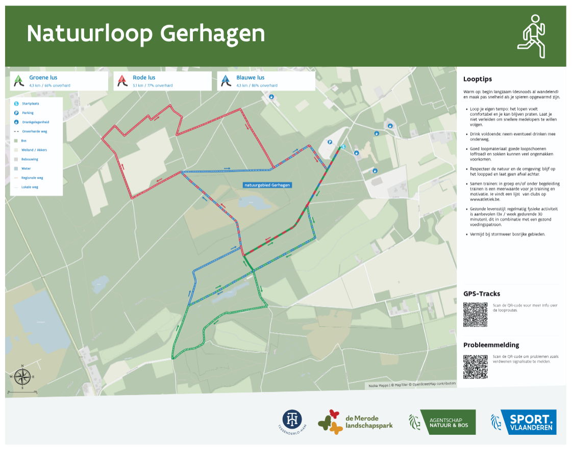
Nazka has been producing a new design for the physical panels for Sport Vlaanderen since the autumn of 2025.
Internationally, we worked on Climate Champions, where together with our partners we are building an application that helps young people in Malawi better understand climate risks and deal with them. In Capitan Taki, we use mapping technology and Earth observation to better monitor the water quality of Lake Tanganyika.
Looking to the past, with Maps in Context and Nostalgeo we demonstrated how combining historical and current context on maps can unlock new stories and experiences. We also contributed to the wonderful MAP Mercator Museum in Sint‑Niklaas, where we helped shape various scenographic elements and interactive map installations — a project that feels like coming home for mapmakers.
We strengthened our role as a data partner with, among others, the Boundaries API, which makes administrative boundaries available as a high‑performance web service, and we put renewed energy into Aircheckr, which makes air‑quality data accessible to a broad audience. And last but not least, in 2025 we welcomed Isabel, Mauro and Faisal for internships, an investment in young talent that we are proud of.
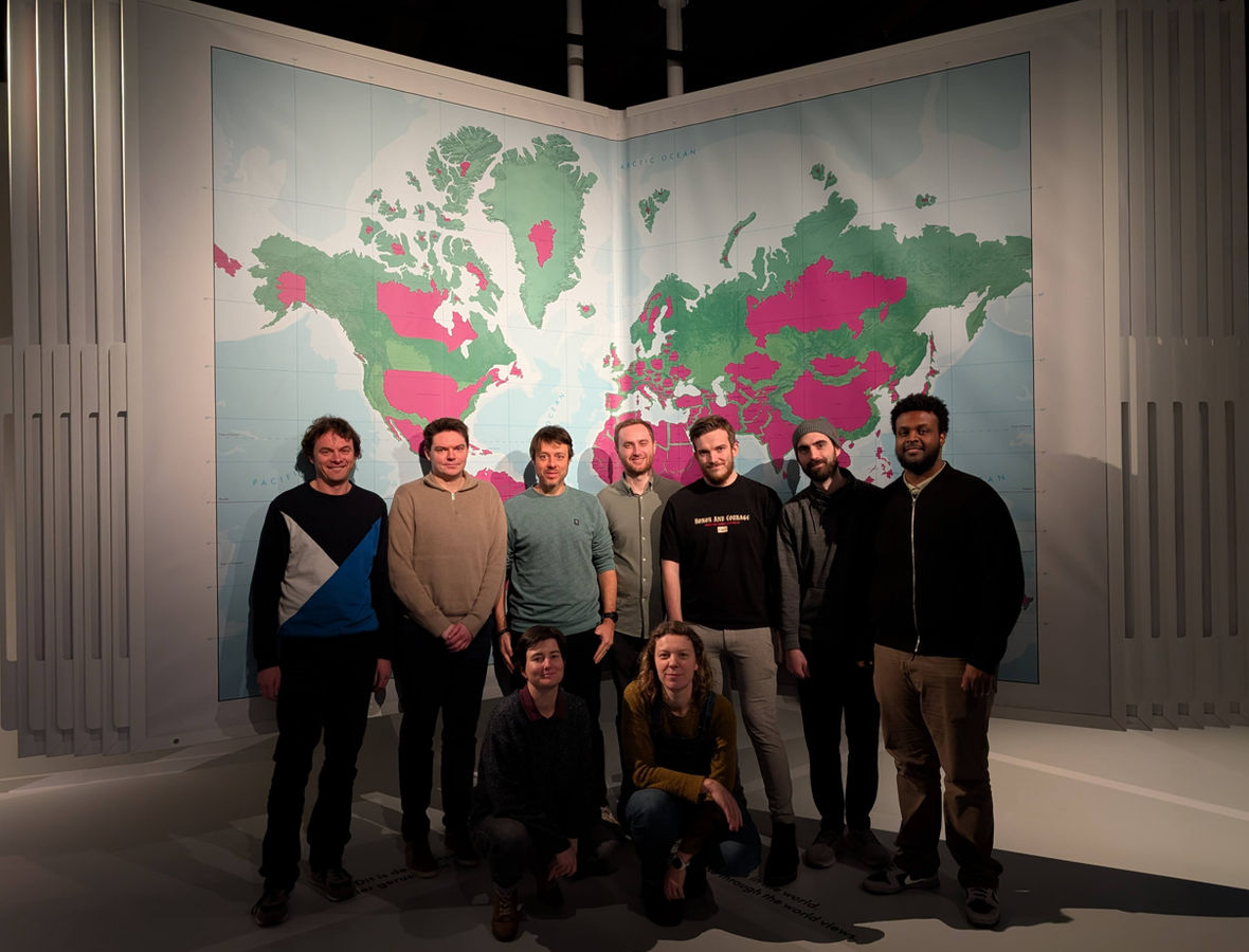
The Nazka team in front of one of our realisations in the MAP Mercator Museum: the Biggest Atlas in the World!
Looking ahead to 2026: AI as both catalyst and challenge
In 2026, artificial intelligence will further transform and profoundly change our sector. AI amplifies our capabilities at every level — from data processing to map design — but at the same time challenges us to keep clearly demonstrating our added value as a specialised mapping partner.
AI makes it easier to build a mapping application yourself or to analyse geodata. But that ease comes at a price: AI‑generated code is often a “black box”; the logic is not very transparent and its structure is hard to manage over the long term. Real, lasting added value only emerges when AI‑produced output is enriched with human expertise and strict validation. The focus here must be on a solid, high‑quality and manageable geostack, in which code and data integrate seamlessly and performantly with existing systems. This is exactly where Nazka makes the difference, with high‑quality, reliable and future‑proof mapping technology you can count on.
AI makes it easier to build a mapping application yourself or to analyse geodata. But that ease comes at a price: AI‑generated code is often a “black box”; the logic is not very transparent and its structure is hard to manage over the long term.
In 2026, we are fully committed to thoughtfully integrating AI as a catalyst in our operations and applications: from smarter workflows for geodata processing, through interactive map assistants, to tools that help us detect patterns, errors or opportunities in code and data more quickly. We experiment deliberately, on a small scale and with an eye for reliability, so that AI does not end up as a gimmick but as an extra layer of quality and efficiency on top of our existing expertise.
Modern GIS for an AI era
Since the start, we have been building what is now known as “modern GIS”: cloud‑native processes and formats as the backbone, with web‑based mapping libraries such as MapLibre, MapTiler and Leaflet as the engine. In an era where AI is increasingly hungry for data, the need for well‑structured, accessible geodata is greater than ever.
Cloud‑native technologies make it possible today to work in a flexible, scalable and cost‑efficient way. Thanks to a smart, lightweight cloud infrastructure, even heavily used interactive maps remain affordable. The time when geodata owners depended on large paid software suites, while only using a limited number of geo-services and functions, is definitively behind us. It is now up to the users of these often overpriced packages to move towards better and cheaper alternatives based on open standards and open‑source building blocks.
The time when geodata owners depended on large paid software suites, while only using a limited number of geo-services and functions, is definitively behind us.
What drives us
Our mission in 2026 remains the same: using our mapping expertise to make a real difference. We do this with pride, craftsmanship and a healthy dose of curiosity. Whether it’s a European innovation call, a highly operational need from the private sector or a Flemish museum project, Nazka continues to work on meaningful, reliable and accessible geodata and maps. By combining domain knowledge, technical innovation and an open‑source mindset, we remain a relevant mapping partner and expert in a rapidly evolving, AI‑driven landscape — and we keep doing what we believe in most: creating mapps that matter.


